|
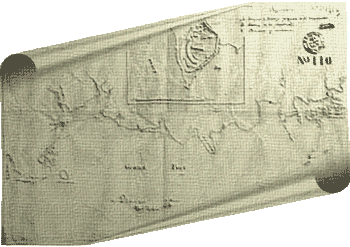
Assiduous archival research in London by Earthwatch volunteer
Alexandra Nichols has located a map which shows the entire bay together with the islets. An inset shows Ile of
Passe (sic) with a list of three recommendations for completions and additions to the defences then existing.
Although this map (Fig. 5), from the National Archives, London, WO 78/71, is undated and unsigned,
the inset is the same as the map that was drawn up by the Lieutenant Robert Smith in 1811 which is reproduced
on p. 37 of Dr Marina Carter's unpublished report and discussed by her on p. 36. Although this map shows
recommendations for additions to the existing defences, there is no evidence that these were ever executed.
The "Ditch", tantalizingly, is not shown, nor are the two sentry posts (Structures 8 and 9), but afoss is
mentioned in an 1811 inventory by Maingard, quoted by Dr Carter on p. 36.
The topographic survey commissioned by the NHT from A. S. Calloo, sworn surveyor,
in 2002 provides the base map for all studies. Ten stations set in concrete form the reference points for current
and future surveying. The map itself is tied to the National Grid of Mauritius.
An arbitrary height of 100m above sea level was given to Station A.
This map was updated after the 2004 season of fieldwork, most notably by the addition of Structures 32
and 33 (Figs 6 and 7). Plans at different scales were also prepared (Figs 8, 9 and 10)
|